California and the Complex Dance of Tectonic Plates
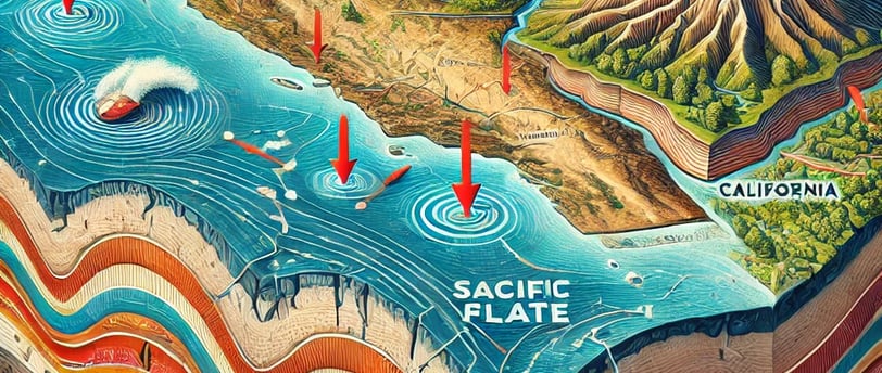
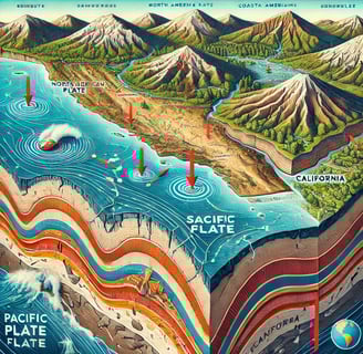
Descripción de la publicación. California's tectonic activity is the product of the Pacific and North American plates converging along a transform boundary.
SCIENCE
Camapa Editorial
11/28/20243 min read
California is one of the most tectonically dynamic regions in the world, a feature that defines its landscape, natural hazards, and geologic evolution. The state's seismic activity and mountainous terrain are the direct result of complex interactions between the North American and Pacific tectonic plates. Understanding California's tectonics is crucial, not only for appreciating its geological formation but also for comprehending the risks associated with earthquakes, which affect millions of people in the region.
The Basics of Plate Tectonics
The theory of plate tectonics explains the movement of Earth's lithosphere, which is broken into large plates that float on the semi-fluid asthenosphere beneath. These tectonic plates are responsible for shaping continents, creating mountains, and generating earthquakes. In California, two major tectonic plates are involved: the Pacific Plate and the North American Plate. The boundary between these two plates is marked by a network of faults that stretches across the state, with the most prominent being the San Andreas Fault.
The San Andreas Fault System
The San Andreas Fault is one of the most famous geological features in the world. It extends roughly 1,200 kilometers (750 miles) through California, from the Gulf of California in the south to Cape Mendocino in the north. This fault represents a transform boundary between the Pacific Plate and the North American Plate. Unlike convergent boundaries where plates collide to form mountain ranges, transform boundaries involve lateral movement, where the plates slide past each other horizontally. This characteristic motion is what gives rise to California's frequent seismic activity.
The San Andreas Fault is a right-lateral strike-slip fault, meaning that, if one stands on either side of the fault and faces it, the opposite side appears to move to the right. This movement is driven by the northwestward motion of the Pacific Plate, which is moving past the North American Plate at an average rate of about 50 millimeters (2 inches) per year. Such movement is not smooth; it builds up stress over time, which is eventually released in the form of earthquakes. The magnitude 7.8 San Francisco earthquake of 1906 and the 6.7 Northridge earthquake of 1994 are vivid reminders of the destructive power of this tectonic setting.
Other Fault Systems in California
While the San Andreas Fault is the most significant, it is by no means the only fault in California. The state is crisscrossed by numerous other faults that contribute to its seismic activity. The Hayward Fault, located in the San Francisco Bay Area, runs parallel to the San Andreas and poses a substantial risk to urban areas. The Garlock Fault, which branches off from the San Andreas Fault in Southern California, is a major east-west fault that separates the Mojave Desert from the Sierra Nevada range. Each of these fault systems adds to the intricate and active tectonic environment of California.
In addition to the strike-slip faults, there are several thrust faults, particularly in Southern California. These faults are responsible for the uplift of the Transverse Ranges, including the San Gabriel and San Bernardino Mountains. Thrust faults differ from strike-slip faults in that they involve vertical movement, where one block of crust is pushed up over another, contributing to the impressive mountain ranges seen throughout the state.
Seismic Hazard and Risk Management
The tectonic complexity of California makes it one of the most seismically active regions in the United States. Earthquakes pose a significant risk to human life and infrastructure, particularly in urban centers like Los Angeles and San Francisco. Understanding the behavior of faults, monitoring seismic activity, and preparing for future earthquakes are all essential elements of managing seismic hazards in California.
The state has implemented various measures to mitigate earthquake risks, including strict building codes designed to withstand strong seismic shaking and an early warning system that provides a few seconds of warning before an earthquake reaches an area. Such preparations are vital, given that scientists estimate a high probability of a major earthquake occurring along the San Andreas Fault within the next few decades.
The Geological Future of California
The ongoing tectonic activity in California will continue to shape its landscape and influence its future. As the Pacific Plate continues to move northwest, geologists predict that, in millions of years, the coastal regions of California could eventually become an island off the North American coast. The relentless pressure between the North American and Pacific Plates will also continue to generate earthquakes and potentially give rise to new geological features.
In conclusion, California's tectonic activity is the product of the Pacific and North American plates converging along a transform boundary. The movement of these plates and the complex network of faults they generate have created a geologically rich and diverse landscape but have also placed the state at constant risk of earthquakes. As our understanding of plate tectonics and fault mechanics improves, California continues to be a natural laboratory for the study of Earth's dynamic processes, offering insights that are crucial for both scientific advancement and public safety.
Camapa Editorial
camapaeditorial@gmail.com
© 2024. All rights reserved.
Our mission at Camapa Editorial is to explore, analyze, and present insights within these fields in a way that both educates and inspires further inquiry. Whether delving into groundbreaking scientific discoveries, examining the intricacies of athletic performance and emerging sports, or exploring the multifaceted world of entertainment, Camapa Editorial aims to be a trusted guide in your journey of learning and exploration.